
Explore the Delaware County Map and view all 3 counties at a glance. Find county names, boundaries, major cities, county seats, population data, and detailed geographic information for Delaware.
All Delaware Counties: Names, Map & County Information
Explore all 3 counties in Delaware with a detailed county list, map, county seats, and key information. Find every Delaware county in one place here.
Delaware County Map Overview
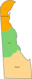
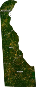
The Delaware County Map provides a clear view of all three counties in the state of Delaware: Kent County, New Castle County, and Sussex County. Although Delaware is the second-smallest U.S. state by land area, it has a rich history and diverse geography. County maps are useful for travelers, students, researchers, businesses, and GIS professionals who need accurate county boundaries and locations.
Delaware's counties vary in population, economy, and landscape. New Castle County is the most populous and includes the city of Wilmington, while Sussex County is known for its Atlantic beaches and tourism. Kent County, located in central Delaware, is home to the state capital, Dover.
Whether you're looking for county boundaries, planning a road trip, studying geography, or working with GIS data, a Delaware county map is an essential resource.
Delaware at a Glance
Delaware County List
Interesting Facts About Delaware Counties
Frequently Asked Questions (FAQ)
How many counties are in Delaware?
Delaware has 3 counties.
What is the largest county in Delaware?
Sussex County is the largest county by land area.
What is the most populated county?
New Castle County has the largest population.
What is the capital of Delaware?
Dover, located in Kent County.
Can I download a Delaware County Map?
Yes. Many GIS and government websites provide downloadable Delaware county maps in PDF, SHP, and GeoJSON formats.
What is Delaware famous for?
Delaware is known as "The First State" because it was the first state to ratify the U.S. Constitution.
Conclusion
The Delaware County Map is a valuable resource for understanding the state's geography, county boundaries, and administrative divisions. Despite having only three counties, Delaware offers a unique combination of historic cities, scenic beaches, agricultural communities, and thriving business centers. Whether you're researching, traveling, or working with GIS data, this map provides an easy way to explore every county in Delaware.