
Explore the complete Alabama County Map guide — all 67 counties, their seats, populations, geography, history, and key facts. Perfect for travelers, students, and researchers.
Introduction
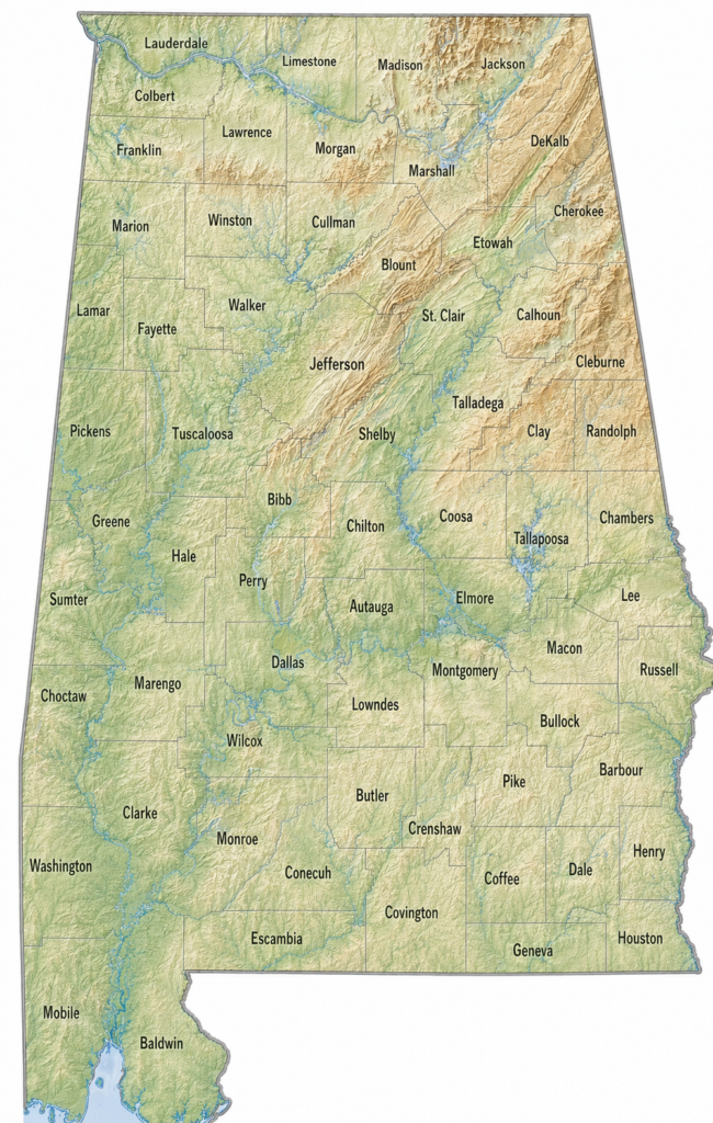
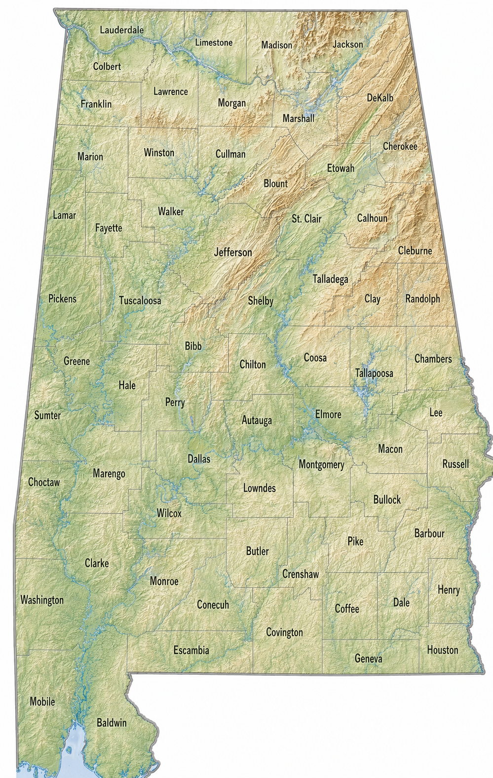
The Alabama County Map is an administrative and geographic map that shows all 67 counties of Alabama — one of the southeastern United States’ most historically significant states. Each county has its own government, court system, school district, and property tax structure, making the county map an essential reference for residents, travelers, investors, and researchers alike.
Alabama is nicknamed the “Heart of Dixie” and stretches from the Tennessee Valley in the north to the Gulf of Mexico in the south. Its 67 counties vary dramatically in landscape, economy, and culture — from the Appalachian foothills of the northeast to the fertile Black Belt prairies of central Alabama and the white-sand beaches of Baldwin County.
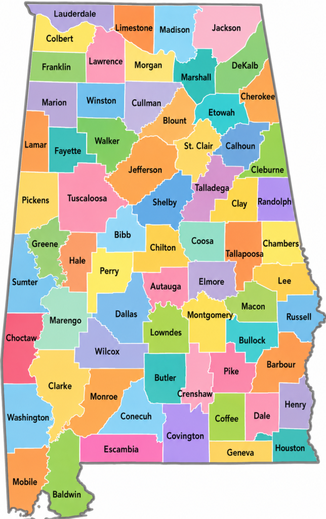
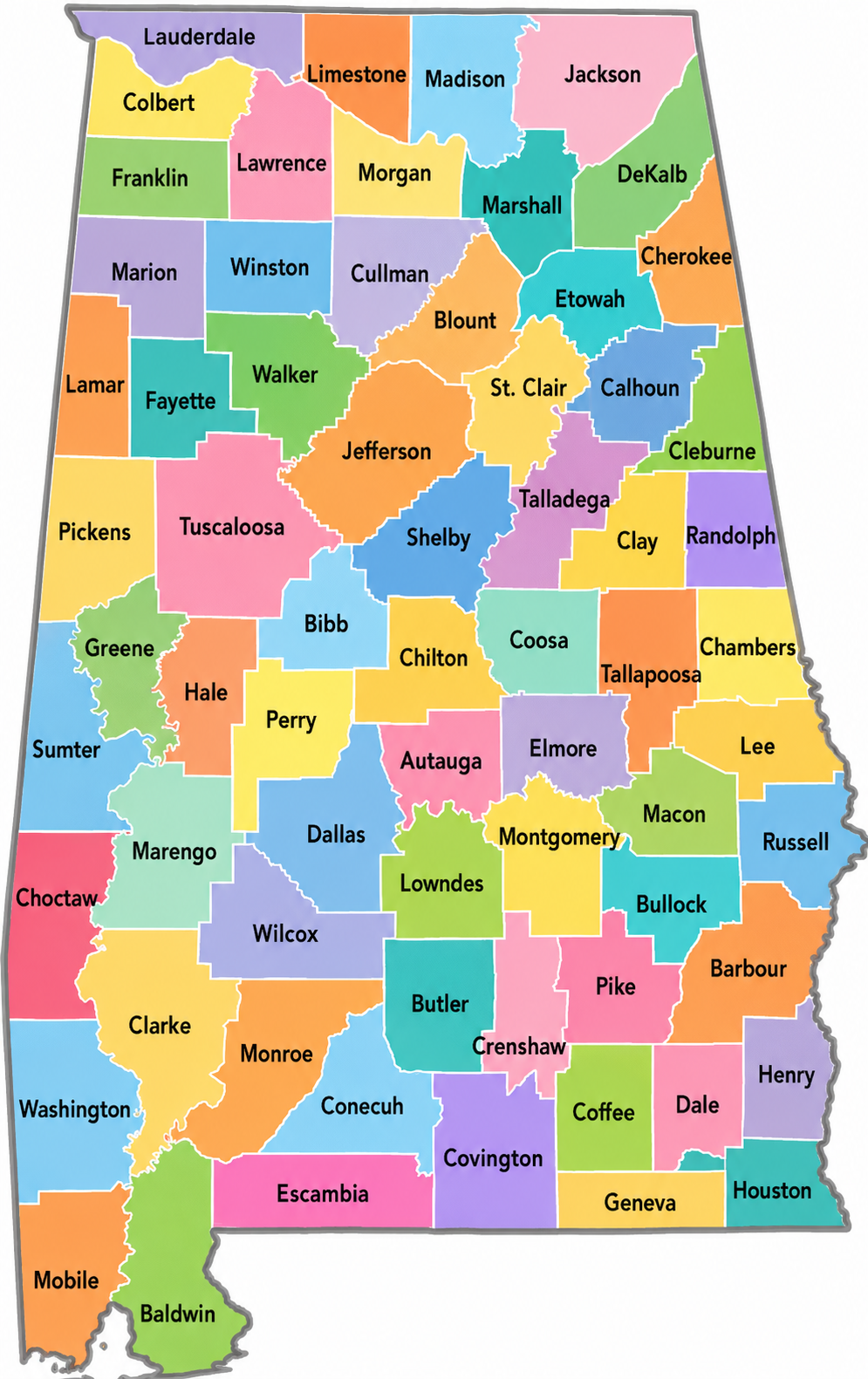
Alabama Satellite County Map
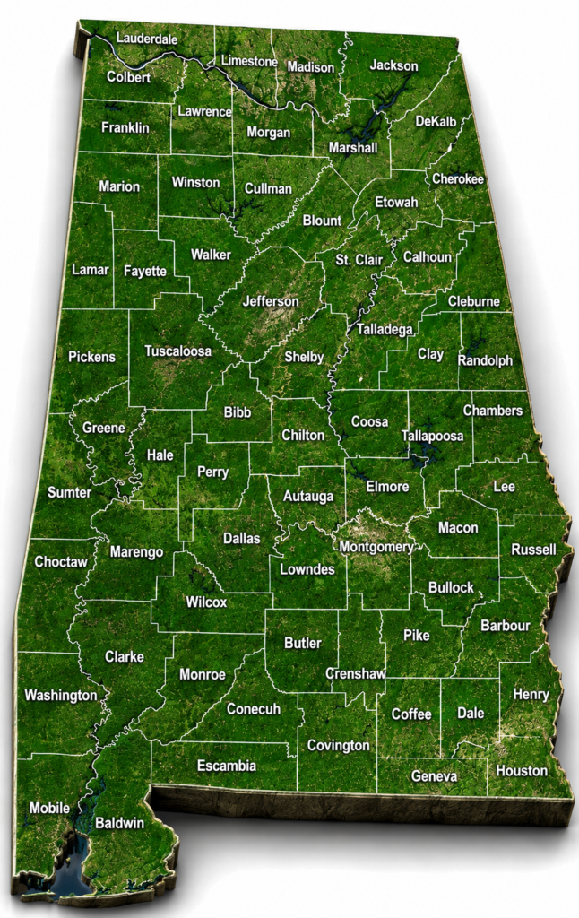
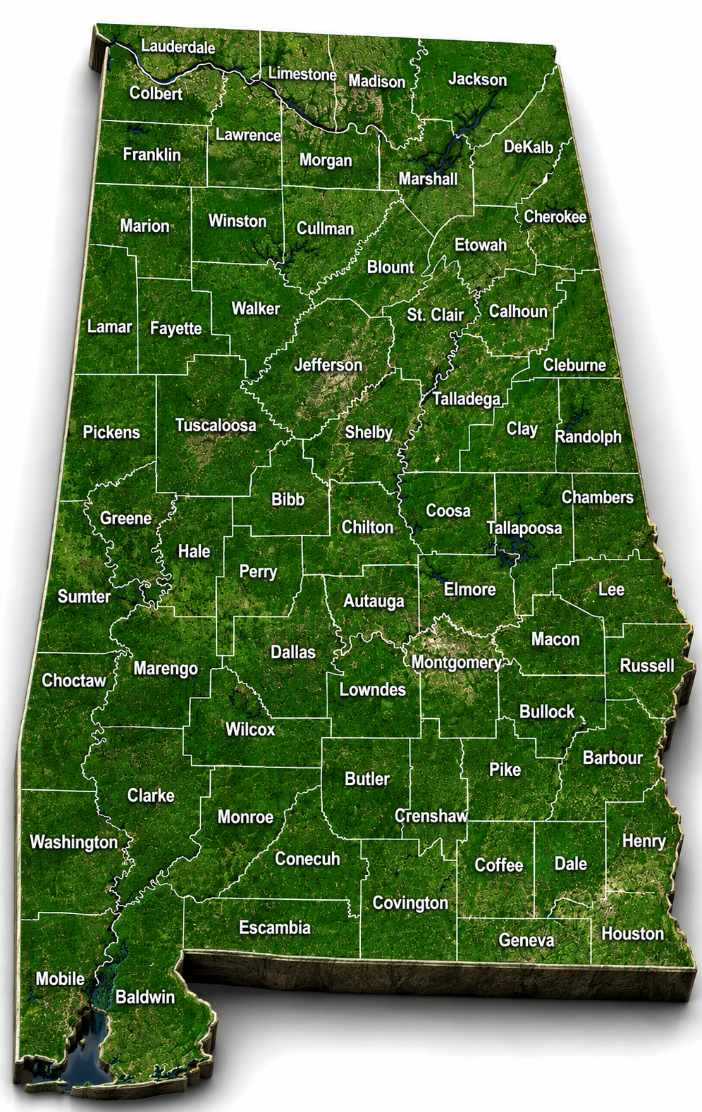
Alabama Topographic County Map
Quick Facts — Alabama County Map
- Total Counties: 67
- State Capital: Montgomery (Montgomery County)
- Largest County by Area: Baldwin County (~1,590 sq. miles)
- Most Populous County: Jefferson County (Birmingham) — 650,000+
- Least Populous County: Cleburne County (~15,000)
- Total State Area: 52,419 square miles
- Year of Statehood: 1819 (22nd state)
- US Rank by Size: 30th largest state
What Is the Alabama County Map?
The Alabama County Map divides the state into 67 distinct administrative units called counties. Every county has a county seat — a central city or town where the local government operates. Counties in Alabama manage roads, courts, property records, elections, and public health services at the local level.
Alabama counties range enormously in size, population, and character. Baldwin County in the south covers nearly 1,600 square miles, while tiny Cleburne County in the east spans just 560 square miles. Similarly, Jefferson County holds over 650,000 residents while several rural counties have fewer than 10,000.
Geographic Regions of Alabama
The Alabama County Map is best understood through three primary geographic regions:
1. Northern Alabama — Tennessee Valley Region Key counties: Madison, Lauderdale, Colbert, Morgan, Lawrence, Limestone, Jackson, Marshall, DeKalb, Blount, Cullman, Franklin, Marion. This region sits in the Tennessee River valley and the southern Appalachian foothills. Huntsville (Madison County) is the dominant city, home to NASA’s Marshall Space Flight Center. The region is known for aerospace, manufacturing, TVA lakes, and outdoor recreation.
2. Central Alabama — Black Belt & Piedmont Key counties: Jefferson, Montgomery, Tuscaloosa, Shelby, Elmore, Autauga, Dallas, Lowndes, Perry, Hale, Bibb, Chilton, Coosa, Talladega, Tallapoosa. This is Alabama’s most densely populated corridor. Birmingham and Montgomery anchor the region. The Black Belt sub-region — named for its dark, fertile soil — was the heart of antebellum cotton production and remains central to Alabama’s civil rights history.
3. Southern Alabama — Gulf Coastal Plain Key counties: Mobile, Baldwin, Escambia, Covington, Coffee, Geneva, Houston, Dale, Butler, Conecuh, Monroe, Clarke, Washington, Choctaw, Wilcox, Crenshaw, Pike, Barbour, Henry, Russell. This flat, low-lying region drains toward the Gulf of Mexico. Mobile is the region’s major port city. Baldwin County’s Gulf Shores and Orange Beach are among the most visited tourist destinations in the Southeast.
County Spotlights — 5 Most Important Counties
Jefferson County — County Seat: Birmingham Alabama’s most populous county. Home to Birmingham, the state’s largest city, UAB Medical Center (one of the top hospitals in the South), and the Birmingham Civil Rights Institute. A major hub for healthcare, banking, and higher education.
Montgomery County — County Seat: Montgomery Home to Alabama’s state capital and one of the most historically significant cities in American history. Montgomery was the first capital of the Confederacy and later became the birthplace of the Civil Rights Movement — Rosa Parks’ arrest, the Montgomery Bus Boycott, and the Selma-to-Montgomery marches all have roots here.
Madison County — County Seat: Huntsville Known worldwide as “Rocket City,” Huntsville hosts NASA’s Marshall Space Flight Center and the U.S. Army’s Redstone Arsenal. Madison County is one of the fastest-growing and highest-income counties in Alabama, driven by a booming aerospace, defense, and technology sector.
Mobile County — County Seat: Mobile Alabama’s only county with direct access to the Gulf of Mexico via Mobile Bay. Mobile is one of the oldest continuously inhabited European settlements in the United States and hosts America’s original Mardi Gras celebration — predating New Orleans by several years. The Port of Mobile is one of the largest ports in the US by tonnage.
Baldwin County — County Seat: Bay Minette The largest county by area in Alabama. Baldwin County’s Gulf Shores and Orange Beach attract millions of visitors annually for their white-sand beaches and clear waters. The county has experienced explosive population growth over the past two decades and is one of the fastest-growing counties in the entire southeastern US.
Complete List of All 67 Alabama Counties
| County | Land % | Water % | Total Area (sq mi) |
|---|---|---|---|
| Autauga County | 98.4% | 1.6% | 604 |
| Baldwin County | 78.4% | 21.6% | 2,027 |
| Barbour County | 97.8% | 2.2% | 905 |
| Bibb County | 99.4% | 0.6% | 626 |
| Blount County | 99.2% | 0.8% | 651 |
| Bullock County | 99.6% | 0.4% | 625 |
| Butler County | 99.1% | 0.9% | 778 |
| Calhoun County | 98.3% | 1.7% | 612 |
| Chambers County | 98.6% | 1.4% | 603 |
| Cherokee County | 97.7% | 2.3% | 590 |
| Chilton County | 98.8% | 1.2% | 701 |
| Choctaw County | 99.1% | 0.9% | 921 |
| Clarke County | 98.2% | 1.8% | 1,253 |
| Clay County | 96.9% | 3.1% | 606 |
| Cleburne County | 98.7% | 1.3% | 561 |
| Coffee County | 98.8% | 1.2% | 680 |
| Colbert County | 96.4% | 3.6% | 622 |
| Conecuh County | 99.0% | 1.0% | 853 |
| Coosa County | 97.7% | 2.3% | 666 |
| Covington County | 99.0% | 1.0% | 1,044 |
| Crenshaw County | 98.9% | 1.1% | 611 |
| Cullman County | 97.8% | 2.2% | 755 |
| Dale County | 98.6% | 1.4% | 563 |
| Dallas County | 97.3% | 2.7% | 994 |
| DeKalb County | 98.5% | 1.5% | 778 |
| Elmore County | 95.8% | 4.2% | 657 |
| Escambia County | 98.5% | 1.5% | 953 |
| Etowah County | 97.4% | 2.6% | 549 |
| Fayette County | 99.0% | 1.0% | 629 |
| Franklin County | 98.5% | 1.5% | 647 |
| Geneva County | 98.6% | 1.4% | 579 |
| Greene County | 98.2% | 1.8% | 660 |
| Hale County | 97.9% | 2.1% | 657 |
| Henry County | 98.3% | 1.7% | 568 |
| Houston County | 98.5% | 1.5% | 582 |
| Jackson County | 97.8% | 2.2% | 1,127 |
| Jefferson County | 96.8% | 3.2% | 1,124 |
| Lamar County | 99.1% | 0.9% | 605 |
| Lauderdale County | 95.9% | 4.1% | 721 |
| Lawrence County | 96.7% | 3.3% | 717 |
| Lee County | 98.3% | 1.7% | 616 |
| Limestone County | 97.7% | 2.3% | 607 |
| Lowndes County | 98.3% | 1.7% | 725 |
| Macon County | 98.3% | 1.7% | 613 |
| Madison County | 97.8% | 2.2% | 813 |
| Marengo County | 97.7% | 2.3% | 983 |
| Marion County | 98.7% | 1.3% | 744 |
| Marshall County | 95.3% | 4.7% | 623 |
| Mobile County | 79.5% | 20.5% | 1,644 |
| Monroe County | 99.0% | 1.0% | 1,034 |
| Montgomery County | 97.5% | 2.5% | 800 |
| Morgan County | 97.2% | 2.8% | 599 |
| Perry County | 98.0% | 2.0% | 724 |
| Pickens County | 98.7% | 1.3% | 890 |
| Pike County | 98.5% | 1.5% | 673 |
| Randolph County | 98.1% | 1.9% | 584 |
| Russell County | 97.8% | 2.2% | 641 |
| St. Clair County | 97.8% | 2.2% | 654 |
| Shelby County | 98.0% | 2.0% | 810 |
| Sumter County | 98.2% | 1.8% | 913 |
| Talladega County | 97.7% | 2.3% | 760 |
| Tallapoosa County | 95.8% | 4.2% | 766 |
| Tuscaloosa County | 97.0% | 3.0% | 1,351 |
| Walker County | 98.1% | 1.9% | 805 |
| Washington County | 98.8% | 1.2% | 1,089 |
| Wilcox County | 97.5% | 2.5% | 911 |
| Winston County | 98.7% | 1.3% | 613 |
Alabama Counties and County Seats
| County | County Seat |
|---|---|
| Autauga County | Prattville |
| Baldwin County | Bay Minette |
| Barbour County | Clayton |
| Bibb County | Centreville |
| Blount County | Oneonta |
| Bullock County | Union Springs |
| Butler County | Greenville |
| Calhoun County | Anniston |
| Chambers County | Lafayette |
| Cherokee County | Centre |
| Chilton County | Clanton |
| Choctaw County | Butler |
| Clarke County | Grove Hill |
| Clay County | Ashland |
| Cleburne County | Heflin |
| Coffee County | Elba |
| Colbert County | Tuscumbia |
| Conecuh County | Evergreen |
| Coosa County | Rockford |
| Covington County | Andalusia |
| Crenshaw County | Luverne |
| Cullman County | Cullman |
| Dale County | Ozark |
| Dallas County | Selma |
| DeKalb County | Fort Payne |
| Elmore County | Wetumpka |
| Escambia County | Brewton |
| Etowah County | Gadsden |
| Fayette County | Fayette |
| Franklin County | Russellville |
| Geneva County | Geneva |
| Greene County | Eutaw |
| Hale County | Greensboro |
| Henry County | Abbeville |
| Houston County | Dothan |
| Jackson County | Scottsboro |
| Jefferson County | Birmingham |
| Lamar County | Vernon |
| Lauderdale County | Florence |
| Lawrence County | Moulton |
| Lee County | Opelika |
| Limestone County | Athens |
| Lowndes County | Hayneville |
| Macon County | Tuskegee |
| Madison County | Huntsville |
| Marengo County | Linden |
| Marion County | Hamilton |
| Marshall County | Guntersville |
| Mobile County | Mobile |
| Monroe County | Monroeville |
| Montgomery County | Montgomery |
| Morgan County | Decatur |
| Perry County | Marion |
| Pickens County | Carrollton |
| Pike County | Troy |
| Randolph County | Wedowee |
| Russell County | Phenix City |
| St. Clair County | Ashville and Pell City |
| Shelby County | Columbiana |
| Sumter County | Livingston |
| Talladega County | Talladega |
| Tallapoosa County | Dadeville |
| Tuscaloosa County | Tuscaloosa |
| Walker County | Jasper |
| Washington County | Chatom |
| Wilcox County | Camden |
| Winston County | Double |
How to Use the Alabama County Map
Real Estate & Property: County boundaries determine property tax rates, zoning laws, and school district assignments. Always verify the county before purchasing land or a home in Alabama.
Travel & Tourism: Use the Alabama County Map to plan trips around specific regions — Gulf Coast beaches in Baldwin County, civil rights history in Montgomery and Dallas counties, NASCAR racing in Talladega County, or space exploration in Madison County.
Business & Investment: Entrepreneurs use county-level demographic and infrastructure data to identify optimal locations for new businesses across Alabama.
Education & Research: Standard in K-12 geography curricula and academic research on Southern US history, demographics, agriculture, and the civil rights era.
Elections & Politics: County-by-county electoral data reveals Alabama’s political trends, which have shifted significantly since the Voting Rights Act of 1965.
Interesting Facts About Alabama Counties
- The oldest Alabama counties are Washington County (est. 1800) and Baldwin County (est. 1809), both formed before Alabama achieved statehood in 1819.
- The “Black Belt” counties — Hale, Perry, Dallas, Lowndes, Wilcox and others — earned their name from the rich dark prairie soil that made them ideal for cotton farming before the Civil War.
- Talladega County is home to Talladega Superspeedway, the longest NASCAR oval track in the world at 2.66 miles.
- Monroe County is the birthplace of Harper Lee, author of To Kill a Mockingbird. The fictional Maycomb County in the novel is based on Monroeville.
- Macon County is home to Tuskegee University (founded 1881 by Booker T. Washington) and was the training ground for the famous Tuskegee Airmen in World War II.
- Shelby County is consistently ranked among the fastest-growing and wealthiest counties in Alabama, driven by suburban expansion from Birmingham.
Frequently Asked Questions
Q: How many counties does Alabama have? Alabama has 67 counties, established progressively after statehood in 1819.
Q: What is the largest county in Alabama by area? Baldwin County, covering approximately 1,590 square miles in southwestern Alabama along the Gulf Coast.
Q: What is the most populous county in Alabama? Jefferson County (Birmingham) with over 650,000 residents.
Q: Which Alabama county has the fewest people? Cleburne County in eastern Alabama, with a population of approximately 15,000.
Q: Where can I find an official Alabama County Map? The Alabama Department of Archives and History, Alabama GIS database, USGS, and Google Maps all provide free official Alabama County Maps.
Q: Which Alabama county is best for tourists? Baldwin County for Gulf beaches, Montgomery County for civil rights history, and Madison County (Huntsville) for space and science tourism.
Q: What county is Auburn University in? Auburn University is in Lee County, Alabama, with Opelika as the county seat.
Conclusion
The Alabama County Map is far more than an administrative tool — it is a window into the remarkable diversity of the American South. Across 67 counties, Alabama tells stories of innovation (Huntsville), courage (Montgomery, Selma), natural beauty (Baldwin, Jackson), and literary greatness (Monroe). Whether you are a student, traveler, investor, or history enthusiast, understanding Alabama’s county map gives you a far richer picture of this extraordinary state.